







A comprehensive scoping review recently published in the International Journal of Geo-Information offers a profound and detailed analysis of the environmental factors essential for inclusive wheelchair navigation. By examining two decades of accumulated global research, the academic paper highlights a critical and long-overdue shift in how society approaches urban accessibility. Instead of relying on rigid, binary "pass/fail" accessibility standards that treat a sidewalk or building entrance as universally accessible or completely barred, researchers and urban innovators are moving toward a far more continuous, personalized approach.
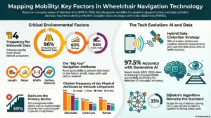
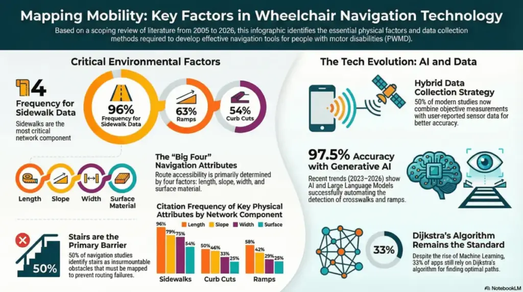
While fundamental physical features—such as sidewalk width, which appeared in 75 percent of reviewed studies, slope at 79 percent, and the presence of functional ramps at 63 percent—remain the most thoroughly documented metrics in academic literature, the study emphasizes a broader truth. True mobility does not depend solely on isolated static measurements. Rather, it relies on the complex, highly individualized interaction between these physical environmental elements and the unique capabilities, energy levels, and confidence of the individual wheelchair user. An environment that poses a minor inconvenience to one person may present an insurmountable barrier to another, depending on their physical strength, equipment type, and personal experience navigating urban terrains.
This vital research underscores an exciting, rapid evolution in the ways cities collect, process, and apply accessibility data. For decades, urban planning and municipal compliance have relied heavily on manual, time-consuming audits. In fact, the scoping review reveals that approximately 50 percent of the studies analyzed still rely on traditional, manual measurements conducted by human inspectors on the ground. However, the most recent body of research, spanning from 2023 to 2026, demonstrates a dramatic, technological surge in the deployment of Artificial Intelligence and machine learning to map and evaluate urban spaces.
Modern technological tools are transforming how municipal authorities understand street-level conditions. For instance, advanced diagnostic applications now utilize everyday smartphone sensors to automatically classify surface vibrations, instantly detecting rough pavement, cracks, or cobblestones based on the movement and feedback of a wheelchair or mobile device. Simultaneously, cutting-edge generative artificial intelligence models are being deployed to detect crosswalks, curb cuts, and pedestrian pathways directly from high-resolution satellite imagery with a remarkable 97.5 percent accuracy rate.
This major technological leap enables cities and researchers to finally integrate real-time "dynamic" factors into accessibility mapping. Historically, variables such as sudden weather changes, accumulated rainwater puddles, temporary construction zones, or fluctuating crowd density were far too difficult to track continuously. With AI-driven infrastructure monitoring, these shifting environmental conditions can be captured, analyzed, and communicated instantly, paving the way for truly responsive smart cities that adapt to daily realities rather than static blueprints.

For urban planners, municipal authorities, and city administrators tasked with designing more inclusive and equitable environments, this wealth of data is invaluable. By targeting the specific factors identified in the two-decade review—such as the precise length, width, and surface quality of urban sidewalks—local governments can move far beyond basic legal compliance. Instead of checking boxes to meet minimum regulatory requirements, authorities can prioritize capital infrastructure upgrades that deliver the highest measurable impact on daily social participation and community integration for residents with mobility impairments.
Furthermore, software developers, civic tech engineers, and navigation system designers can leverage these comprehensive findings to fundamentally refine routing algorithms. For generations, digital mapping services and GPS applications have focused almost exclusively on identifying the shortest or fastest physical path from one point to another. Armed with the insights from this scoping review, developers can implement sophisticated multi-objective routing models. These advanced systems can account for a user’s specific confidence levels, physical fatigue thresholds, and energy expenditure requirements, effectively guiding travelers around steep inclines, heavy construction, or poor surface conditions that would otherwise force them to turn back.
The implications of this research extend directly into the medical and therapeutic communities. Healthcare professionals, occupational therapists, and clinical rehabilitation specialists can utilize these detailed insights to gain a much clearer understanding of how external environmental barriers interact with a patient’s functional skills during recovery or long-term adaptation. By integrating these robust environmental metrics into clinical assessments and occupational therapy sessions, medical teams can provide much more realistic, practical training and guidance for wheelchair users preparing to navigate unfamiliar, complex urban settings independently.
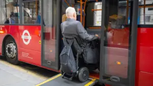
Ultimately, the data compiled in the scoping review serves as an essential roadmap for creating a seamless, multimodal mobility experience. When pedestrian infrastructure networks, intelligent street design, and accessible public transit systems work together in harmony, they create an urban ecosystem that actively supports personal independence rather than undermining it.
By bridging the gap between theoretical accessibility standards and the lived, everyday realities of wheelchair users, this extensive review highlights a clear path forward for modern society. Embracing AI-driven data collection methods and personalized, adaptive routing algorithms allows urban centers to transform from frustrating, obstacle-filled landscapes into genuinely inclusive spaces that foster full social participation. As technology continues to bridge the gap between human capability and persistent environmental barriers, the long-held vision of a truly accessible city transitions from an idealistic goal into an attainable, everyday reality.