









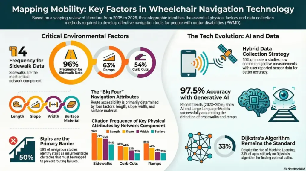
A recent scoping review published in the International Journal of Geo-Information provides a comprehensive and timely analysis of the environmental factors that are essential for inclusive wheelchair navigation in modern urban spaces. By examining two decades of accumulated research, the paper highlights a significant and long-overdue shift from traditional, rigid "pass/fail" accessibility standards toward a much more continuous, personalized approach that accounts for the fluid realities of city life.
For decades, urban accessibility has largely been defined by binary compliance checklists—doors are wide enough or they are not, ramps are present or they are missing. However, this new review demonstrates that true mobility is far more nuanced. While foundational physical features—such as sidewalk width, which appeared in 75% of the analyzed studies, sidewalk slope at 79%, and the presence of ramps at 63%—remain the most heavily documented structural factors, the study emphasizes that true mobility ultimately depends on the complex, day-to-day interaction between these static elements and the individual capabilities, fatigue levels, and confidence of the user.
The research underscores an exciting technological evolution in how cities collect, analyze, and process accessibility data. While half of the studies analyzed still rely on traditional, manual measurements and physical audits, the latest body of research spanning from 2023 to 2026 demonstrates a dramatic surge in the utilization of Artificial Intelligence and machine learning technologies. Modern tools have moved far beyond the clipboard and measuring tape. For instance, contemporary navigation applications and municipal monitoring systems now utilize smartphone sensors to automatically classify surface vibrations, instantly detecting bumpy cobblestones or cracked pavement. Furthermore, developments in generative AI allow researchers and city planners to automatically detect crosswalks, curb cuts, and sidewalk obstructions from satellite imagery with a remarkable 97.5% accuracy rate.

This technological leap allows for the seamless integration of real-time, "dynamic" factors that were previously far too difficult or labor-intensive to track systematically. Variables such as fluctuating weather conditions, seasonal accumulation of puddles or snow, temporary construction zones, and shifting crowd densities can now be monitored and factored into urban transit equations. By capturing these transient obstacles, mapping technology can paint a much more accurate picture of what a wheelchair user actually encounters when attempting to navigate a city block on any given day.

This wealth of data is proving to be incredibly valuable for urban planners and city authorities who are tasked with designing and maintaining more inclusive public environments. By targeting the specific structural factors identified in the literature—such as the precise length, width, and surface quality of sidewalks—municipal decision-makers can move well beyond basic legal compliance. Instead, they can prioritize targeted infrastructure upgrades that deliver the highest possible impact on daily social participation and civic life. Rather than blindly allocating funds, cities can use these insights to pinpoint exact bottlenecks in pedestrian networks.
Furthermore, software developers and geospatial engineers can use these comprehensive research findings to fundamentally refine routing algorithms. For too long, digital mapping services have prioritized the shortest possible physical distance between two points, a metric that is often completely unsuited for wheelchair users who might face insurmountable slopes, missing curb cuts, or impassable construction barriers along a nominally direct route. By applying the insights from this scoping review, developers can implement multi-objective routing models. These advanced models can account for a user’s unique confidence levels, preferred modes of transit, and energy expenditure, effectively routing individuals around obstacles that would otherwise render a journey stressful or impossible.
Beyond municipal planning and software engineering, healthcare professionals and clinical rehabilitation specialists can also utilize these insights to better understand how complex environmental barriers interact with a patient’s physical skills and functional independence. By integrating these robust environmental metrics into clinical evaluations and occupational therapy sessions, rehabilitation experts can provide much more realistic, context-aware training and guidance for wheelchair users preparing to navigate unfamiliar urban settings. Ultimately, the data serves as a vital roadmap for creating a more seamless, multimodal mobility experience where pedestrian networks, accessible micro-mobility infrastructure, and public transit systems work in tandem to support long-term autonomy.
In conclusion, this extensive scoping review serves as a crucial bridge connecting theoretical accessibility standards with the lived, everyday reality of wheelchair users. By embracing AI-driven data collection methods and personalized, dynamic routing algorithms, modern urban centers have a clear pathway to transform from obstacle-filled landscapes into truly inclusive spaces that foster robust social participation. As technology continues to bridge the gap between human capability and persistent environmental barriers, the vision of a genuinely accessible city transitions from an idealistic goal into an attainable reality for municipalities worldwide.