







A comprehensive scoping review recently published in the International Journal of Geo-Information offers a profound look into the environmental factors that dictate inclusive wheelchair navigation, marking a critical turning point in how urban spaces are understood, evaluated, and designed. By analyzing two decades of scholarly research, the paper highlights a fundamental transformation in accessibility studies. For years, city design and compliance standards have relied on rigid, binary "pass/fail" metrics. However, the new review reveals an encouraging shift toward a continuous, highly personalized approach that aligns infrastructure with human reality.
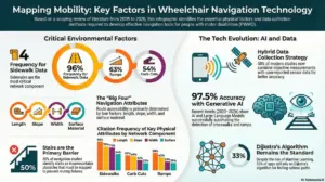
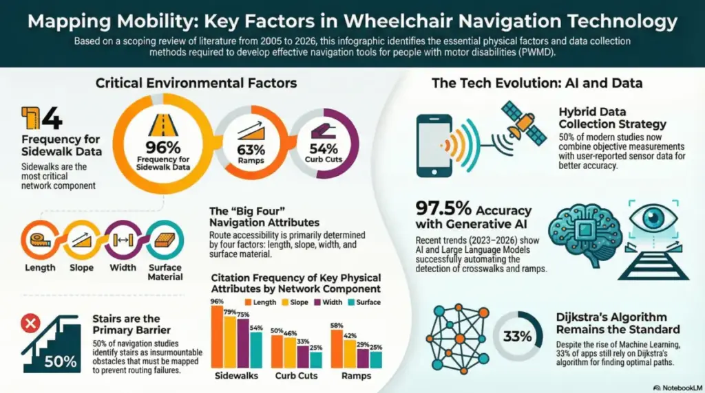
While physical characteristics of the built environment remain foundational to urban mobility, their documentation underscores what researchers have long suspected: true accessibility is not merely about ticking boxes. According to the study, physical features such as sidewalk slope, width, and the presence of ramps continue to dominate the literature, appearing in 79%, 75%, and 63% of analyzed studies, respectively. Yet, the authors of the review emphasize that a static measurement tells only part of the story. True mobility emerges from the intricate, dynamic interaction between these physical elements and the unique, individual capabilities of the wheelchair user navigating them.
This realization arrives alongside a technological revolution in how accessibility data is gathered, processed, and applied. For decades, mapping urban landscapes for people with mobility impairments was a painstaking, manual endeavor. In fact, the review notes that half of all historical studies analyzed still rely heavily on traditional, manual measurements. However, a closer examination of the research published between 2023 and 2026 uncovers a dramatic surge in the adoption of artificial intelligence and advanced machine learning techniques.

Modern data collection is increasingly automated and remarkably precise. Contemporary tools now harness smartphone sensors to automatically detect and classify surface vibrations, allowing mapping systems to instantly identify bumpy cobblestones, cracked pavement, or smooth asphalt. Similarly, cutting-edge generative AI models are now capable of analyzing satellite imagery to detect crosswalks with an astonishing 97.5% accuracy rate. This technological leap has unlocked the ability to integrate real-time "dynamic" factors—such as shifting weather conditions, puddles, construction zones, and fluctuating crowd densities—variables that were previously far too complex or transient to track consistently.

For urban planners and city authorities tasked with shaping the cities of tomorrow, this wealth of data provides an unprecedented roadmap. Armed with granular insights into specific environmental bottlenecks, such as the exact length and surface quality of sidewalks within a given neighborhood, decision-makers can move well beyond basic regulatory compliance. Instead of investing resources haphazardly, they can prioritize infrastructure upgrades that yield the highest possible impact on daily social participation and community integration for residents with mobility challenges.
Simultaneously, software developers and navigation engineers are uniquely positioned to translate these research findings into practical, everyday tools. Conventional routing applications typically calculate the fastest or shortest path from point A to point B, a method that often inadvertently directs wheelchair users toward steep inclines, missing curb cuts, or impassable barriers. By incorporating the insights from this scoping review, developers can design advanced multi-objective routing models. These sophisticated algorithms can account for a user’s specific energy expenditure, physical fatigue, and personal confidence levels, intelligently steering them away from obstacles that would otherwise render a route completely insurmountable.
The implications of this research extend deeply into the medical and therapeutic fields as well. Healthcare professionals, occupational therapists, and rehabilitation specialists can utilize these comprehensive environmental metrics to gain a more holistic understanding of how external barriers intersect with a patient’s functional skills. By integrating real-world environmental data directly into clinical assessments and rehabilitation programs, specialists can offer more realistic, practical training and guidance, better preparing wheelchair users to navigate unfamiliar urban landscapes with confidence and autonomy. Ultimately, this data serves as a vital blueprint for building a seamless, multimodal mobility experience where pedestrian networks, accessible infrastructure, and public transit systems operate in unison to support lasting independence.
By bridging the historic divide between theoretical accessibility standards and the lived, everyday experiences of wheelchair users, this scoping review underscores the immense potential of modern innovation. As cities continue to embrace AI-driven data collection, intelligent infrastructure, and personalized routing algorithms, urban centers can gradually transition from fragmented, obstacle-filled landscapes into genuinely inclusive spaces. Technology continues to narrow the gap between human capability and environmental barriers, bringing the long-held vision of a truly accessible, smart city closer to an everyday reality for millions of people.