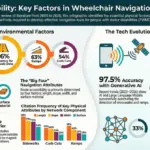









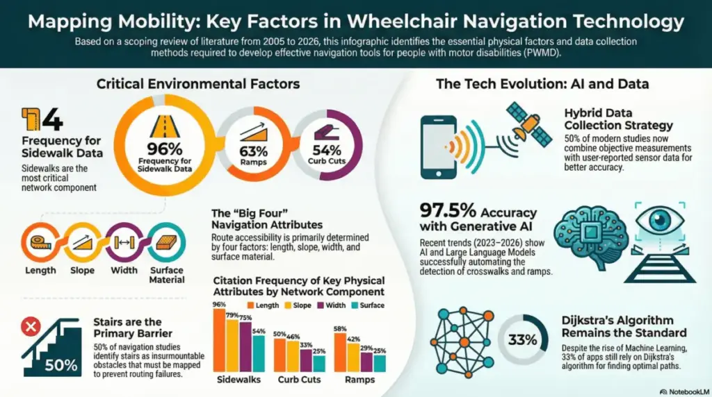
A recent scoping review published in the International Journal of Geo-Information provides a comprehensive and timely analysis of the environmental factors essential for inclusive wheelchair navigation. By examining two decades of research, the paper highlights a significant, long-overdue shift from rigid, binary “pass/fail” accessibility standards toward a more continuous, personalized approach that better reflects the realities of urban life. While physical features like sidewalk width, slope, and the presence of ramps remain the most documented elements in the literature, the study emphasizes that true mobility does not rely on static measurements alone. Instead, it depends on the complex interaction between these physical elements and the user’s individual capabilities, energy levels, and navigation preferences.
For decades, urban accessibility has been measured through a blunt lens. Sidewalks either met a specific code or they did not; ramps were either present or absent. However, this new academic review reveals a growing consensus among researchers, urban designers, and disability advocates that the lived experience of navigating a city is far more nuanced. A sidewalk that technically meets width requirements may still prove impassable if it is slick with rain, obstructed by outdoor dining furniture, or cracked by tree roots. By charting two decades of scientific literature, the review captures how the field is finally moving past simplistic compliance checklists to embrace the dynamic, multifaceted nature of urban movement.
The research underscores an exciting evolution in how cities and researchers collect, process, and apply accessibility data. While roughly half of the analyzed studies still rely on traditional, manual measurements—such as inspectors physically walking routes with measuring wheels and leveling tools—the latest research from 2023 to 2026 demonstrates a dramatic surge in the use of Artificial Intelligence and machine learning. This technological leap is fundamentally transforming how spatial data is gathered and updated, shifting the burden from slow, manual audits to rapid, automated intelligence.
Modern technological tools are now capable of feats that were once considered science fiction. For instance, advanced navigation apps and research prototypes currently use smartphone sensors to automatically classify surface vibrations, instantly detecting whether a user is rolling smoothly over fresh asphalt or jarringly bouncing across broken pavement. Similarly, researchers are deploying generative AI to analyze satellite and street-level imagery, detecting crosswalks, curb cuts, and potential obstacles with a remarkable 97.5% accuracy rate. This technological leap allows for the seamless integration of real-time “dynamic” factors—such as sudden weather conditions, temporary construction zones, or shifting crowd densities—that were previously far too difficult to track and map on a city-wide scale.

This wealth of fresh, granular information is proving to be incredibly valuable for urban planners and city authorities who are tasked with designing more inclusive and resilient urban environments. Municipalities often operate under tight budget constraints, making it crucial to deploy resources where they will yield the greatest benefit for the community. By targeting the specific factors identified in the research—such as the exact length, connectivity, and surface quality of pedestrian pathways—planners can move far beyond basic legal compliance. Instead, they can prioritize infrastructure upgrades that have the highest tangible impact on daily social participation, economic engagement, and overall quality of life for residents with mobility impairments.
Furthermore, software developers and engineers can use these comprehensive findings to significantly refine and improve routing algorithms. Traditional mapping applications typically offer the absolute shortest path from point A to point B, a metric that can easily direct a wheelchair user down a terrifyingly steep hill or onto a heavily cracked, inaccessible sidewalk. By leveraging the insights from this scoping review, developers can implement multi-objective routing models. These advanced systems account not only for distance, but also for a user’s specific confidence levels, physical strength, and energy expenditure, effectively mapping routes that bypass obstacles and inclines that would otherwise prove insurmountable.
Beyond municipal offices and tech boardrooms, the findings hold profound implications for clinical settings. Healthcare professionals and rehabilitation specialists can utilize these insights to gain a much deeper understanding of how physical environmental barriers directly interact with a patient’s developing or established functional skills. By integrating these comprehensive environmental metrics into clinical evaluations and occupational therapy sessions, practitioners can provide far more realistic, practical training and guidance for wheelchair users preparing to navigate unfamiliar, complex urban settings. Ultimately, this data serves as a vital roadmap for creating a more seamless, multimodal mobility experience where pedestrian networks, accessible public transit, and smart city infrastructure work harmoniously together to support long-term independence.
This extensive scoping review serves as a crucial bridge between theoretical accessibility standards and the everyday lived reality of wheelchair users worldwide. By aggressively embracing AI-driven data collection methods and sophisticated, personalized routing algorithms, modern society has a unique opportunity to transform urban centers from obstacle-filled landscapes into genuinely inclusive spaces that foster robust social participation. As technology continues to bridge the gap between human capability and persistent environmental barriers, the visionary ideal of a truly accessible city is steadily becoming an attainable, everyday reality.