







A comprehensive scoping review recently published in the International Journal of Geo-Information offers a profound look into the complex environmental factors essential
for truly inclusive wheelchair navigation. Analyzing two decades of academic and urban research, the study documents a vital paradigm shift in how modern societies approach accessibility. For years, urban design relied heavily on rigid, binary "pass/fail" standards that merely checked boxes for compliance. However, this new body of research highlights a transition toward a continuous, personalized approach that accounts for the diverse, real-world experiences of wheelchair users traversing modern metropolitan landscapes.
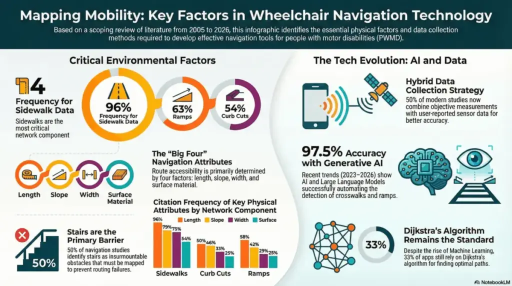
While foundational physical characteristics—such as sidewalk width, which appeared in 75% of the analyzed studies, pavement slope at 79%, and the presence of ramps at 63%—remain the most frequently documented variables, the research emphasizes a critical insight. True urban mobility is not determined by static measurements alone, but rather by the intricate interaction between these physical elements and an individual user’s unique capabilities, energy levels, and equipment specifications. A sidewalk that technically meets width requirements may still present an insurmountable barrier if it suffers from poor surface degradation, unexpected crowding, or unmanaged weather hazards.
The publication underscores an exciting evolution in the methodology of collecting and processing spatial accessibility data. Historically, urban mapping required tedious, manual audits conducted by researchers or city inspectors on foot. In fact, the scoping review reveals that 50% of the studies analyzed still rely on these traditional, manual measurement techniques. Yet, a pronounced technological surge spanning from 2023 to 2026 demonstrates a rapid integration of Artificial Intelligence (AI) and advanced machine learning into urban planning frameworks.
Modern engineering tools are increasingly leveraging everyday technologies to automate data collection. For instance, advanced mobile applications now utilize built-in smartphone sensors to automatically detect and classify surface vibrations, giving planners precise data on pavement roughness and bumps without requiring manual surveys. Simultaneously, generative artificial intelligence has advanced to the point where algorithms can analyze satellite and street-level imagery to detect crosswalk markings with an astonishing 97.5% accuracy rate.

This technological leap has unlocked the ability to incorporate real-time, dynamic factors into accessibility mapping. In the past, tracking variables like fluctuating crowd densities, temporary construction zones, or sudden weather events—such as large puddles, snow accumulation, or ice patches—was virtually impossible on a city-wide scale. Today, AI-driven systems can process these transient conditions dynamically, bridging the gap between static infrastructure maps and the fluid, unpredictable realities of daily city life.
These research findings carry profound implications for urban planners and municipal authorities tasked with designing more inclusive and resilient civic environments. By shifting focus toward the specific, granular factors identified in the review—such as precise sidewalk length, continuous connectivity, and surface quality—decision-makers can move far beyond basic legal compliance. Instead, cities can strategically prioritize infrastructure upgrades that yield the highest possible impact on daily social participation and community integration.
Furthermore, software developers and navigation engineers are uniquely positioned to translate these insights into next-generation routing algorithms. Conventional mapping software typically offers users the shortest or fastest path from one point to another, which can inadvertently direct wheelchair users onto hazardous or exhausting routes. By adopting multi-objective routing models informed by this research, developers can create systems that account for a user’s personal confidence levels, propulsion endurance, and energy expenditure. This ensures that navigation tools actively help individuals avoid obstacles, steep inclines, or poorly maintained surfaces that would otherwise render a route impassable.
Healthcare professionals and clinical rehabilitation specialists also stand to benefit greatly from integrating these insights into their practices. Understanding how specific environmental barriers interact with a patient’s functional skills allows clinicians to bridge the gap between controlled rehabilitation settings and unpredictable outdoor environments. By incorporating real-world environmental metrics into clinical assessments and mobility training programs, specialists can offer more realistic, practical guidance for patients preparing to navigate unfamiliar urban settings independently. Ultimately, this data serves as a vital roadmap for creating a seamless, multimodal mobility experience where pedestrian pathways, accessible public transit, and intelligent routing technologies work in tandem to support autonomy.
Ultimately, this extensive scoping review acts as a crucial bridge connecting theoretical accessibility standards with the lived experiences of wheelchair users across the globe. By fully embracing AI-driven data collection methodologies and personalized, intelligent routing algorithms, modern metropolitan areas have the opportunity to transform from fragmented, obstacle-filled landscapes into truly inclusive spaces that actively foster community engagement and social participation. As technological innovations continue to bridge the historical divide between human capability and persistent environmental barriers, the long-held vision of a genuinely accessible city moves closer to becoming an attainable, everyday reality.